by Geoffrey Smart
Tide Tables
The major unknown element for the sea kayaker is the weather. Wind, rain and ocean swells are affected by changing weather conditions and the prudent paddler will always check the forecast before a trip. Although tides and currents up to 6 knots are a major factor in the San Francisco Bay, they are not a mystery. From earliest times it has been understood that tides are produced by the gravitational pull of the moon and the sun. Knowing the cycle of these bodies in their orbits allows us to predict with a high degree of accuracy the times and magnitude of tides and currents. This data is now provided by the National Oceanic & Atmospheric Administration (NOAA) and assumes normal weather and normal seasonal variations. Heavy rainfall, low barometric pressure and strong onshore winds increase tides, while the opposites decrease them. It is vital that paddlers are able to read and understand tide tables since they contain valuable information that will minimize risk and maximize enjoyment.

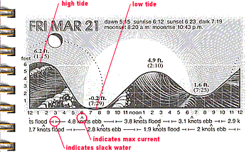
Probably the easiest tide table to read is the Tidelog® produced by Pacific Publishers in Tybee Island, GA. Their almanac has a daily graphic (see example at right) that contains the following information displayed in a straightforward visual manner: dawn, sunrise, sunset, dark; moonrise, moon phase, moonset; slack water, maximum ebb and maximum flood, all set against a 24-hour representation of tide height. Beneath the graphic, the upper line of data is for currents at the S.F. Bay Entrance and the lower line for the Carquinez Straight. Note that times of high tide and low tide (which determine how far water comes up the beach), do not correspond with maximum current (the speed that the water is flowing) nor with slack water (zero current). The reason for this is explained in the section on Tides and Currents. Refer to the Glossary for more definitions.
In the back of the Tidelog® are tide and current corrections for places up and down the coast including San Francisco Bay, San Pablo Bay and parts of the Delta as far up as Sacramento. There is also a series of maps that show S.F. Bay currents at hourly intervals before and after maximum ebb and flood at the Golden Gate.

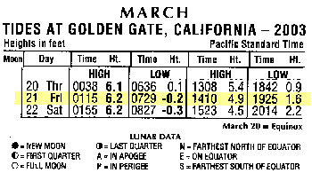
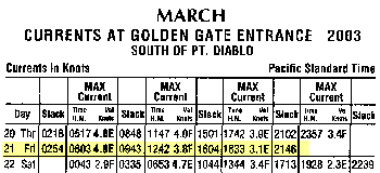
BASK has its own tide book thanks to Ken Mannshardt, who every year tries to get at least one into the hands of every member. It's a third the size of the Tidelog®, yet contains nearly all of same information only in tabular form. Each month has two tables on facing pages, showing tides and currents at the Golden Gate (see examples at right) and the Carquinez Strait. A nice feature of the tide book is that exact times are given for slack and maximum current. (Note: the printing in the Tidelog® and the tide book is considerably easier to read than these Internet images).
Of interest to the kayaker on this particular date, Friday March 21st, 2003, slack water at 9:45 AM brings an end to the early morning ebb. Maximum flood of 3.8 knots occurs around 12:45 PM with a high tide of 4.9 feet at 2:10 PM. The flood ends with slack water at 4:00 PM and the ebb begins, rising to a maximum of 3.1 knots at 6:30 PM, just after the sun sets. The moon doesn't rise until 10:43 PM later that evening. In other words, a perfect day for a late morning launch at Horseshoe Cove. Ride the flood to Angel Island for a late afternoon picnic then ride the ebb back in time for cocktails at the Presidio Yacht Club.
Tides and Currents
In order to understand the relationship between maximum current, high and low tides and slack water, consider the situation in the open ocean. When the tide flows (pulled by the gravitational force of the moon and the sun), the maximum rate of flow occurs during the two hours of mid-flow; as it approaches high water the rate of flow slackens until there is no appreciable movement. The same pattern occurs on the ebb. It can be seen that slack water coincides with high and low tides and that maximum flow occurs half way between them.
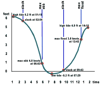
Now consider the situation at the Golden Gate (see graph at right). Note that maximum current again occurs roughly half way between two periods of slack water, but that slack water no longer coincides with high and low tides. In this example, slack water after high tide is approximately 1 hour and 40 minutes later; slack water after low tide is approximately 2 hours and 10 minutes later. The principle reason for this is inertia: it takes time to fill and drain the Bay through the narrow opening of the Golden Gate. This is why, in the example shown in the Tidelog® above, the maximum flood of 1.9 knots at the Carquinez Bridge occurs 2 hours after maximum flood at the Gate. In other words, that "bulge" of water takes 2 hours to travel the 25 miles between the Golden Gate Bridge and the Carquinez Strait.
Unlike the simple curve in the Tidelog®, the curve on this graph not only indicates water height at different times but also the varying magnitude of the current. The flatter the curve the less current, the steeper the curve the greater the current. I have forgotten all I ever knew about calculus, but I know there's a formula in there somewhere...
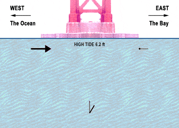
The animated image (shown at right) illustrates the relationship between maximum current, high and low tides, and slack water. In order for the image to repeat indefinitely, it uses a twelve hour cycle rather than the actual twelve hours and forty minutes between successive high tides. The size of the arrows is intended to illustrate the varying current flowing past the north tower of the Golden Gate Bridge. The arrows also indicate that slack water is the result of the equal and opposite flow of water, rather than the absence of flow, per se.
The cycle begins with high tide at 1 AM illustrating that although the water level begins to recede, it is still moving into the Bay until the rate of flood diminishes to the point where it is balanced by water beginning to flow out of the Bay, and which produces slack water at 3 AM. Thereafter, the ebb increases to a maximum of 4.8 knots at 6 AM, followed by low tide at 7:30 AM. The ebb then diminishes until it is balanced by the growing flood at 9:30 AM. The flood increases and the cycle repeats endlessly.
Glossary
Current—The flowing of water in one direction. Measured in knots. Currents may be affected by tides, wind, barometric pressure, temperature and geography.
Ebb—Outgoing tidal current draining a body of water.
Flood—Incoming tidal current filling a bay or other body of water.
High tide—The highest point that the water level will reach in a tide cycle.
Knot—One nautical mile per hour. 1 knot = 1.15 mph. 0.87 knots = 1 mph. The misused phrase "knots per hour" is not only incorrect because it's redundant, but it makes you sound like a land lubber. (Lubber n. Big clumsy fellow, lout; clumsy seaman.)
Low tide—The lowest point that the water level will reach in a tide cycle.
Max ebb—The maximum rate of flow of water as it recedes.
Max flood—The maximum rate of flow of water as it rises. An approximate rule for both the amount of the rise and the speed of the flow of a flood tide for each of the six hours of the period of the tide is 1/12 for the first hour, 2/12 for the second, 3/12 for the third and fourth, 2/12 for the fifth, and 1/12 for the sixth.
MLLW—Mean Lower Low Water is the average of the lower of the two daily low tides. This level is used as the zero mark when measuring tides. It is the same datum that is used on a chart to indicate soundings (or depths of water).
Nautical mile—6,080 feet or one minute of latitude. (A statute mile is 5,280 feet).
Neap tides—Tides of minimal change. They occur during the first and third quarters of the moon, when the pull of the sun is at right angles to the pull of the moon. The effect of this is to make the high tide lower and the low tide higher with minimal currents.
Slack water—The period in the tide cycle when there is little or no current. Slack water occurs approximately halfway between maximum ebb and maximum flood and can last for 15 to 45 minutes. It is said that during this period bird life in and around estuaries becomes quiet.
Spring tides—Those tides that rise highest and fall lowest. Spring tides occur when the sun and moon are in line (whether 0° or 180° apart) and act together. These conditions occur twice in each lunar month, so that there are two spring tides and two neap tides every twenty nine days. Note: The term "spring" tides is not related to the season.
Tide—The vertical rise and fall of the sea as caused by the moon and the sun. In mid ocean, it is six hours and 20 minutes between high and low water. Near the coastline and particularly at the mouths of large rivers and estuaries, the period can vary slightly. Tides vary because of the moon's proximity, phase and declination. Tide tables predict the time and height of tides along the coast, measured above a chart datum, usually mean lower low water (MLWW).
Tidal race—A localized area of exceptionally fast tidal currents. They occur at certain times of the tide cycle and are usually caused by a topographical anomally. BASKers favorite tidal race is Yellow Bluff, just north of Cavallo Point and Horseshoe Bay.
Back to Technical and Gear