This section provides guidelines and information about areas around the San Francisco Bay and Point Reyes National Seashore that are either completely off-limits to kayakers or that have limited or seasonal access. For convenience, we have highlighted Special Closures and divided the Bay Area into four regions: San Francisco Bay, San Pablo Bay, South Bay/San Mateo Coast, and Gulf of the Farallones (which includes Point Reyes, Tomales Bay, and Bodega Bay).
Jurisdiction within this area varies to a bewildering degree. For example, there is military property (portions of Hunter's Point & Mare Island still fall under military jurisdiction), private property (such as the vast salt flats at the end of the South Bay and the Oil Industry terminals and facilities), port authorities and municipal/county jurisdictions, plus areas under the US Fish & Wildlife Service, the National Park Service (e.g. the Golden Gate National Recreation Area and the Point Reyes National Seashore), the Greater Farallones National Marine Sanctuary, California State Parks (including Tomales Bay State Park and Angel Island State Park), and the East Bay Regional Park District (including Brooks Island).
Special Closures
As of May 1, 2010, six marine protected area special closures important to kayakers are in effect along the California Coast from Half Moon Bay to Point Reyes. Special closures protect sensitive seabird colonies and are off limits to boaters. The special closures are listed here and described further down on this page.
- Devil’s Slide Rock Special Closure
- Double Point and Stormy Stack Special Closure, Point Reyes
- Point Resistance Rock Special Closure, Point Reyes
- Point Reyes Headlands Special Closure
- Southeast Farallon Island Special Closure
- North Farallon Islands Special Closure
Other marine protected areas restrict or prohibit fishing, but do not restrict boating. See more information and maps.
San Francisco Bay
An area bounded by the Golden Gate, the Richmond/San Rafael bridge and the Bay bridge with major shipping lanes intersecting the bay in the direction of each of these bridges. The three major ports are Point Richmond, Oakland, and San Francisco.
- Alcatraz Island
 is under the jurisdiction of the National Park Service and is closed to all boaters for landing. This famous island in the center of San Francisco Bay is the nesting area for many bird colonies. Keep at least 300 feet away from the island or nesting cormorants will be scared off their nests and waiting seagulls can dive in to eat the chicks. This is a common scenario along many bird colonies now with the increased frequency of kayakers; many well-intentioned kayakers just aren't aware of their impact. From over 10 years of collecting data, biologists have found that the birds are easily disturbed by small non-motorized boats approaching within 300 feet from the island during their breeding season from March to August.
 - Brooks Island is a 373-acre island off Point Richmond once used as a water-fenced compound for animal stock, then a private pheasant hunting preserve; now it's a reserve for nesting terns, herons, and egrets. It's closed to all boaters landing.Two caretakers oversee the island and tours can be arranged through East Bay Parks.
- Castro Rocks just south of the Richmond San Rafael bridge and north of the Standard Oil pier is a known harbor seal haul-out.
- Crissy Field [www.parksconservancy.org/programs/crissy-field-center] is under the jurisdiction of the National Park Service and has recently undergone a major restoration to return it to its natural state. The area of shoreline from the airfield to the entrance to the lagoon (which is a water bird protection area), is closed to kayakers. Further eastwards, in an area popular with wind surfers, launching is permitted from the sandy beach with adjacent car parking.
- McLaughlin Eastshore State Park [www.ebparks.org/parks/eastshore/] is a park in progress. It will eventually join 1,817 acres, or approximately five miles, of shoreline from Emeryville to Point Richmond. It will open in stages as environmental cleanup and restoration progresses. It's the joint effort of the East Bay Regional Park District and the State of California. Currently sections of the shoreline have signs, hazards, and private -no landing- restrictions.
- Point Bonita/Rodeo Beach The following areas are now closed to boating within 300 ft. of shore: 1) The shoreline of Bonita Cove east of Point Bonita and 2) The area around Bird Island (aka Bird Rock) off Rodeo Beach. See this Park Service Memo for more information.
- Richardson Bay [https://richardsonbay.audubon.org/] The northeastern portion of Richardson Bay is a 900-acre water bird sanctuary run by the Richardson Bay Audubon Center that provides public education programs focusing on wetlands and the San Francisco Bay, migratory birds, and endangered species.
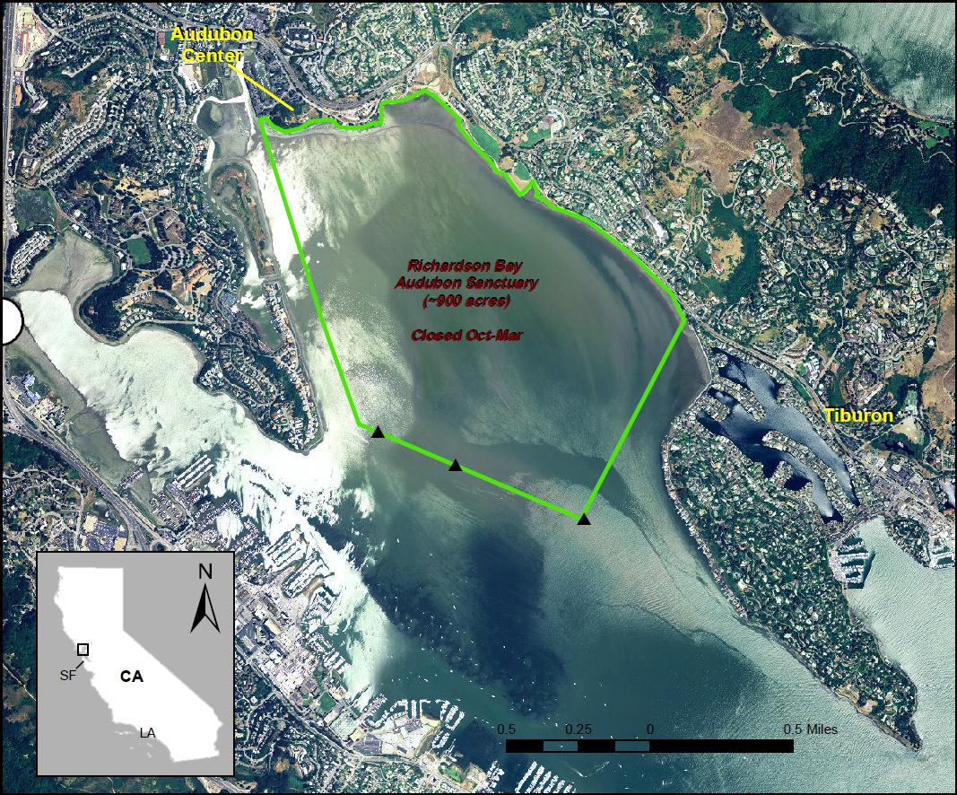 The sanctuary closes to all watercraft from October 1 through March 31 of each winter. The area is marked on the south and west with seasonal buoys and by three permanent cement pilings on the southern boundary.
- San Quentin Prison in the 1970s some inmates escaped in a makeshift kayak. Generally speaking, it's best to keep at least 100 feet from shore and not try to come in for a look. The guards will yell warnings and if you do not obey, the situation could escalate into a confrontation! You have been warned.
San Pablo Bay
This vast area north of the Richmond/San Rafael bridge has many areas to avoid for a variety of reasons.
- Castro Point - HAZARD immediately north of the Richmond/San Rafael bridge, the Castro Point Pier is falling apart and has become a submerged water hazard to boaters.
- The Brothers these two rocky islands are hosts to cormorants, gulls, pelicans, and the East Brother Lighthouse. The lighthousekeeper's 1873 home is now a stunning bed & breakfast. Landing is not allowed without prior arrangement. Boaters will note that water is funneled extremely quickly between the two islands during a strong ebb or flood tide.
- Mare Island, opposite Vallejo, has a long history of being a Navy shipyard—from building paddlewheel gunboats in 1859 to nuclear submarines up to 1970. In 1996, it was turned over to civilian use. It's located in an area of extensive mudflats, but kayaking is possible on Dutchman Slough off the Napa River. Along the South side of the slough is Cullinan Ranch, managed by US Fish and Wildlife, previously closed to public, but a kayak launch is now available there.
- Marin Islands National Wildlife Refuge and State Ecological Reserve, often referred to as the San Rafael Islands, are under the jurisdiction of the U.S. Fish and Wildlife Service, monitored by the San Rafael Police, and off-limits and closed to all. The two islands of 3 and 10 acres may be approached for bird watching, but you must keep 100 feet from shore.
- Point Molate to Point Orient Landing is not allowed between these two points just north of the Richmond/San Rafael bridge. The area belongs to the US Navy and is in process of being transferred to the City of Richmond.
The South Bay/San Mateo Coast
The South Bay a huge, multi-use area. The northern end is used as a shipping anchorage for the Port of Oakland. There are two major airports, miles of mud flats, and at the southern tip, salt ponds.
- Corkscrew Slough (part of Don Edwards) south of Bair Island is open for kayaking (although there are seal haulouts and exposed birdlife), but the small waterways north of it are off limits.
- Don Edwards San Francisco Bay National Wildlife Refuge [www.fws.gov/refuge/don_edwards_san_francisco_bay/] is under the jurisdiction of the U.S. Fish and Wildlife Service. [Call the USFW headquarters for areas used for hunting and dates they are off-limits (415) 792-0222]. This 21,000-acre refuge extends from Alameda Creek near Interstate 92 in the East Bay to Coyote Creek at the extreme end of South Bay, to Steinberger Slough near 92 in the West Bay. It essentially includes all the hills, marshes, and waterways, and provides protection for habitat and wildlife, several of which are endangered. The general rule is: all sloughs (with restrictions) are accessible, but all salt marshes and salt ponds are off limits. No landing is allowed above the high tide mark and disturbance of wildlife or habitat is open to citation. Many sloughs empty at low tide and if stranded, it's requested to wait for the next tide. The mud is deep and can be dangerous. One can get stuck permanently! When kayaking, follow the Viewing Wildlife guidelines and also maintain a distance from rafts of birds on the open water. Harbor seals are particularly sensitive here unlike the seals of the North Bay and Elkhorn Slough. Wildlife has little protective cover, especially during the higher tides and in winter. Forcing it from cover exposes it to easy predation. Observe posted signs and watch for seasonal closures.
- Mowry Slough in the far South Bay is closed March 15 to June 15 for seal pupping.
- Mallard Slough off Coyote Creek, is closed March 1 to August 31 for heron nesting and is also closed approximately mid-October to mid-January for duck hunting.
- Devil’s Slide Rock (Egg Rock) to Devil's Slide Special Closure on the coast is just north of Half Moon Bay, and hosts a colony of over 3,000 nesting Common Murres. It's closed year-round to boating. Map and more information.
Gulf of the Farallones
Paddle out under the Golden Gate bridge and you can paddle north, south, and west, but you'd better know what you're doing: wind and weather, surf, and swells can upset even the most experienced paddler.
- Point Reyes National Seashore [https://www.nps.gov/pore/index.htm] is under the jurisdiction of the National Parks Service. The north and south shore beaches on the Pacific side should be considered dangerous for all but the most advanced kayakers in the best of conditions. Launching and landing at Drakes Beach or Limantour Beach is more advisable. The northwestern corner of Drake's Beach has good access to the ocean side of Point Reyes. Numerous closures affect kayaking as well as road access to the peninsula. To protect harbor seals from disturbance during the most crucial part of the pupping season (from March 1 through June 30), the National Park Service has closed the following areas to the public: Drakes Estero, Estero de Limantour, Double Point, and the western end of Limantour Spit. Duck Island and the east side of Hog Island are closed to the public year-round. See Kayaking Around Point Reyes National Seashore and A Guide to Low Impact Boat Camping for more information.
- Point Reyes Special Closures The following colonies are located on Point Reyes and are prohibited to all boating year round:
- Double Point and Stormy Stack Special Closure
Just S of Alamere Falls. Read more about this area.
See https://nrm.dfg.ca.gov/FileHandler.ashx?DocumentID=91615&inline. - Point Resistance Rock Special Closure
SE of Limantour Beach. See https://nrm.dfg.ca.gov/FileHandler.ashx?DocumentID=91614&inline. - Point Reyes Headlands Special Closure
See https://nrm.dfg.ca.gov/FileHandler.ashx?DocumentID=91611&inline.
- Double Point and Stormy Stack Special Closure
- Drake's Estero [www.nps.gov/pore/planyourvisit/kayak.htm] is closed every year from mid-March to the end of June. Exact dates depend on the timing of the Harbor Seal pupping season. The bays within the Estero are open to paddlers. In addition to these closings, there are seasonal closures on a number of beaches with the Point Reyes National Seashore.
- Bolinas Lagoon [marincountyparks.org/parkspreserves/preserves/bolinas-lagoon] is under the jurisdiction of Marin County Parks. Kayaking there is legal; however, it's highly recommended that paddlers follow the posted launch sites and practice good wildlife viewing etiquette.
- Estero San Antonio Although some of the surrounding property owners would like kayakers to think that these waterways are private lakes, they fall under the jurisdiction of the Greater Farallones National Marine Sanctuary. Paddling on the Estero San Antonio is a unique experience, but access is difficult and virtually "closed" to the public at all times. Sometimes it can be accessed from the ocean.
- Estero Americano is accessible year-round, although care must be taken to avoid disturbing the abundant wildlife. Please follow the Viewing Wildlife guidelines. It's important to watch the tides when paddling the Esteros, as there are some very shallow spots.
- Greater Farallones National Marine Sanctuary [https://farallones.noaa.gov/] This 1,255-square mile area along the coast of California north and west of San Francisco is located between 38°18' N and 37° 29' N latitude. The shoreward boundary of the sanctuary follows the mean high tide line between Bodega Head (Sonoma County) to Rocky Point (S. of Steep Ravine in Marin County), except along the Point Reyes National Seashore, where it follows the seaward boundary of the park that extends a quarter mile off shore. Within the sanctuary, fishing is legal; however, removing mussels, clams, starfish, or any other tide pool life is illegal. Damaging or removing historical or cultural resources is also illegal.
- Horeshoe Cove on Bodega Head in Sonoma County is managed by the Bodega Marine Reserve. The Bodega Marine Laboratory is located on the Reserve. Access to the beach by land is restricted to researchers with prior approval to access the Reserve. Kayakers are prohibited from trespassing above the mean high tide line; the manager of the reserve has politely asked us not to land here to avoid disturbing ongoing experiments. BASK strongly encourages kayakers to comply and please avoid this cove.
- Tomales Bay is home to many species of wildlife. During summer, fall, and winter months, brown pelicans roost on islands and floats and on shore. These birds are protected under the Endangered Species Act and any disturbance including flushing is prohibited, so keep at least 100-200 feet away. Other seabirds that are protected by the Migratory Bird Treaty Act include common murres, cormorants, and western gulls. Avoid any areas where birds are resting on shore. The east side of Hog Island is closed to provide a haul-out site for harbor seals. Give them a berth of at least 300 feet when they are on land and 50 feet in the water. Pelican Point is closed at all times to provide a roosting place for pelicans. South Blue Gum Beach (approximately opposite Lawson's Landing) is closed March 15 to June 30 for seal protection. See Kayaking Around Point Reyes National Seashore and A Guide to Low Impact Boat Camping for more information.
- Farallons Special Closures The following colonies are located on the Farallon Islands and prohibit boating seasonally. Pay close attention to these maps if you are visiting the islands.
- Southeast Farallons Island Special Closure See https://nrm.dfg.ca.gov/FileHandler.ashx?DocumentID=91770&inline.
- North Farallon Islands Special Closure See https://nrm.dfg.ca.gov/FileHandler.ashx?DocumentID=91777&inline.