The Geology of Some Favorite Bay Area Kayaking Destinations
by Doerte Mann. Published in Bay Currents, August 2004.
Download this article as a PDF file (350 KB).
Paddling around Pt. Bonita last spring, I realized what a great reminder of our geological history the kayak seat offers. These cliffs, these rocks, the source of our paddling pleasures and pains today, have preserved the long history of the geological processes that formed them millions of years ago, and that have shaped them ever since. We should take some time to listen to those rocks, because the story they tell us is quite extraordinary.
The Big Picture: Plate Tectonics
The surface of the Earth is not a rigid and stationary crust, but broken up into several pieces, or plates, that are constantly moving relative to each other. The motion of these plates is driven by forces deep inside the Earth. All the processes that cause, and events that result from, this motion, are summarized by the term plate tectonics.
The tectonically most active places are along the boundaries of the plates, where the plates interact with each other. The three main types of plate boundaries are: 1. Spreading centers, where new ocean floor is generated and plates are moving away from each other, 2. Subduction zones, where an oceanic plate meets a continental plate, and because of its greater density sinks underneath the continental plate, and 3. Transform faults, where two plates shear against one another in a lateral motion.
Remnants and current evidence for all three types of plate boundaries can be found in the San Francisco Bay Area. And, best of all, many are best visited by kayak!
Geological History of the Bay Area
Understanding the geological history of the Bay Area is the key to understanding the rocks we see today. Today, a transform fault, the San Andreas, marks the boundary between the North American and the Pacific Plates, and runs right through our paddling grounds (see Location 3 below). It hasn't been like this forever. Further back in geological history, between approximately 100 and 200 million years ago, the boundary was a subduction zone, also called the Franciscan subduction zone. Then, the oceanic Farallon Plate was sinking beneath the North American Plate. Many rocks in the Bay area remain from this era (Locations 1 and 2).
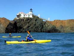
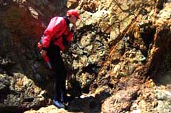
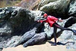
Location 1: Point Bonita/Marin Headlands
The Pt. Bonita lighthouse is built on pillow basalts. The basalt was formed far away from its current location, when magma rose at the East Pacific Rise spreading center, cooled, and created new basaltic ocean floor. Magma that erupts under water has a characteristic structure that looks like a pile of pillows. The newly generated basaltic oceanic crust slowly moved away from the spreading center. During this long journey, marine sediments were constantly deposited on top of the basalt, consisting of organic as well as inorganic material. The slow settling of microorganisms with a silica-rich shell onto the ocean floor created a thick layer of chert. Upon approaching the continental shelf of the North American Plate, sediments coming from the continent were deposited on top of the chert, solidifying into sandstone.
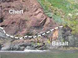
When the layers of basalt-chert-sandstone entered the subduction zone, they were compressed and severely folded. Part of the assemblage was subducted beneath the North American Plate, but another part of it was simply attached, or accreted, to it. This is what happened to the rocks that now make up the Marin Headlands, and large parts of the Californian coast. Excellent exposures of pillow basalts can be found at Tennessee Pt., from the south end of Rodeo Beach to Pt. Bonita, at Pt. Diablo, in Kirby Cove, and at Lime Pt. The overlaying chert is reddish in color and often beautifully folded. It can be seen at the east ends of Bonita and Kirby Coves, at Lime Pt., and at several other locations in the Bay, like Red Rock. Most of the cliffs in Bonita Cove are made of sandstone that deposited on top of the chert.
In some places, the original layering of basalt, chert, and sandstone can easily be identified, but in other places it seems to be just a big jumble of rocks. And that's exactly what it is—call it "mélange", and you sound like a pro.
Location 2: Angel Island
Angel Island exhibits rocks similar to those at Pt. Bonita and the Marin Headlands, except that they have been metamorphosed. This means, they sank to greater depth in the Farallon subduction zone and have been altered by the high pressure and elevated temperatures present at those depths. Therefore we find squeezed pillow basalts, schistose sandstones, chert converted to blueschist, and metamorphosed material from the great depth of the earth mantle, called serpentine.
To get the most geology out of a trip to Angel Island, we'll land on Perle's beach first. At the west end of the beach are excellent exposures of pillow basalts. At the east end, we find layers of highly metamorphosed sedimentary rock: schist. The schist comes in two varieties: green and blue. Of special interest is the blueschist.
It only forms under high pressure and relatively low temperatures—exactly as they occur in subduction zones. Therefore, blueschist is a reliable indicator for the past or present existence of subduction. Also at the east end of Perle's beach are exposures of foliated serpentine. It was generated when magma rose from great depth to the surface at the East Pacific Rise spreading center, and was hydrothermally altered upon contact with salt water.
Then, circumnavigating the island, keep your eyes open for pillow basalts on the west side, with some imbedded sparkles of blueschist. The greenschist is mostly exposed at the Point southeast of Perle's beach. A variety of sandstones can be seen throughout the island. Landing at the beach at Camp Reynolds, the interesting seawall should be checked out. It was mainly constructed from sandstone, and shows a special pattern of erosion by evaporation of sea spray. This is called honeycomb weathering and is caused by salt crystals prying sand grains out of the sandstone.
Location 3: Tomales Bay/Pt. Reyes
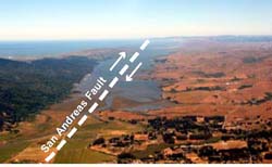
On Tomales Bay, we are paddling right on today's plate boundary, the San Andreas Fault. To the west is the Pacific Plate, moving northwest; to the east is the North American Plate, moving relatively southeast, at a rate of approximately one inch per year. The plate interfaces are rough surfaces, and they are not lubricated very well. This means there is a lot of friction between them, and their relative motion generates strain. This strain builds up over the years, and when it reaches a threshold, it is released in a sudden event, an earthquake. Paddling our kayaks on Tomales Bay during an earthquake, we probably wouldn't even feel it, because we would not be directly connected to the shaking rocks.
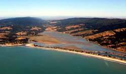
On the west side of Tomales Bay, the rock is mostly granite. This is quite different from all the other rocks we have identified so far. Where does it come from? Subduction of the Farallon Plate caused melting of rocks at depth, facilitated by the addition of watery sediments that decreased the melting temperature of the rocks. The molten rock, or magma, rose towards the surface, but cooled and stopped moving before it reached the surface, crystallizing into granite. Later, this granite was uplifted, and the sediments around it eroded. Today, it makes up most of California's Sierra Nevada. However, part of the granitic intrusions extended further to the west. When the San Andreas fault became active approximately 28 million years ago, the granite was located on the west side of the fault. Due to the lateral motion of the fault, it then got transported from its original location near Pt. Conception in Southern California, northward to its current location, the west shore of Tomales Bay.
In most other parts of the Pt. Reyes Peninsula, the granite is overlain by younger sediments, sand and dunes. But granite is also exposed at the Pt. Reyes Headlands, at the lighthouse and in the cliffs near the lifeboat station. In the future, the Pt. Reyes Peninsula together with this granite will continue its journey north.
While the ever-changing waves immediately wash away any evidence of us kayakers on the ocean, the rocks that border it have endured a much longer history. When paddling, they provide us with beautiful views and towering cliffs. They give us arches, caves, and slots to play in. They also tell the story of their creation and their presence on Earth. And the appreciation of their story adds to our paddling experience during our brief lifetimes.
Further reading:
Geology of the San Francisco Bay Area by Doris Sloan. University of California Press, 2006.
Geologic Trips: San Francisco & the Bay Area by Ted Konigsmark. Geo Press, 1998.
Back to Miscellaneous Articles